Rio Grande Rift Crustal Deformation Measurements Using GPS
an NSF-Earthscope Project


--Frequently Asked Questions About the Rio Grande Rift--

Most of the network has finished recording and been decommissioned, but 11 sites are still logging data! Click here for a summary of the current status of the network!

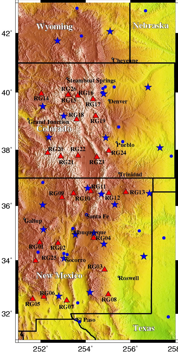
The red triangles in the map below represent Rio Grande Rift network GPS station locations. If you want to know more about a particular site, click on a triangle below or the site link at right to get details.

Click here to find out what a GPS site installation looks like!

Site RG14Site RG26Site RG16Site RG17Site RG18Site RG19Site RG20Site RG21Site RG22Site RG23Site RG24Site RG09Site RG10Site RG11Site RG12Site RG13Site RG01Site RG02Site RG03Site RG04Site RG05Site RG06Site RG07Site RG08Site RG25

The Goal Of This Project is to measure GPS motions in the Rio Grande Rift to address the following questions:

  • What controls extension within "narrow" continental rifts and how does rifting relate to lithospheric heterogeneity?
  • What earthquake hazard does the Rio Grande Rift pose?
  • Is deformation steady or episodic?
  • Does observed Quaternary fault slip agree with geodetic strain rates?
  • How wide is the rift, and how does strain vary along strike?
  • How far north has the Rio Grande Rift propagated?
  • How does rift propagation manifest in Neogene rotation of the Colorado Plateau?
  • What is the influence of mantle rheology, and how does deformation style depend on strain rate?


  • Site RG01 near Pie Town, NM
  • Site RG02 near Belen, NM
  • Site RG03 near Capitan, NM
  • Site RG04 near Encino, NM
  • Site RG05 near White Signal, NM
  • Site RG06 near Faywood, NM
  • Site RG07 near Las Cruces, NM
  • Site RG08 near Hope, NM
  • Site RG09 near Lindrith, NM
  • Site RG10 near Cebolla, NM
  • Site RG11 near Taos, NM
  • Site RG12 near Cimarron, NM
  • Site RG13 near Dorsey Mansion State Park, NM
  • Site RG14 near Meeker, CO
  • Site RG15 near McCoy, CO
  • Site RG16 near Heeney, CO
  • Site RG17 near Empire, CO
  • Site RG18 near Twin Lakes, CO
  • Site RG19 near Tarryall, CO
  • Site RG20 near Red Mountain Pass, CO
  • Site RG21 near Creede, CO
  • Site RG22 near Del Norte, CO
  • Site RG23 in Great Sand Dunes National Park, CO
  • Site RG24 near Rye, CO
  • Site RG25 near Datil, NM
  • Site RG26 near McCoy, CO


  • Rio Grande Rift GPS

    Interested in teaching about Earthquake Hazards in Colorado? Visit CU Science Explorers!

    Also, Please Visit the Rio Grande Rift GPS: New Mexico Website and UNAVCO's Rio Grande Rift: Colorado page!


    Investigators, Collaborators and Participants

    University of Colorado

  • Anne Sheehan
  • Steve Nerem
  • Henry Berglund
  • Walter Szeliga
  • Adam Nokes
  • Monica Guerra
  • Susanna Gross
  • Susan Buhr
  • Mark McCaffrey
  • Daynna Rodosovitch
  • Jill Haynie
  • Rachelle Richmond
  • University of New Mexico

  • Mousumi Roy
  • Matt Nyman
  • Emily Jones
  • Kristen Mullen
  • Amy Luther
  • Nicolas George
  • Utah State University

  • Tony Lowry
  • Jared Romero
  • UNAVCO

  • Freddy Blume, Project Manager
  • Nicole Feldl, Project Engineer
  • Kyle Bonnenstiel
  • Ellie Boyce
  • David Kasmer
  • Jim Normandeau
  • Thomas Nylen
  • Jay Sklar


  • In the News...


    This material is based upon work supported by the National Science Foundation under grant number 0454541. Any opinions, findings, and conclusions or recommendations expressed in this material are those of the authors and do not necessarily reflect the views of the National Science Foundation.


    This site was created by Tony Lowry
    with contributions from other project members.
    Last Update: 27 June 2012